Showing posts with label hiking. Show all posts

Tuesday, July 5, 2022

Truckventure: Tygh Creek Road

 Over 4th of July weekend we finally had good weather and free time to go check out some rustic camping along Tygh Creek Road. A neighbor friend suggested this area last summer after we got the truck but we didn't make it out before the road closed for the winter.

The view from our campsite. Can you believe there was a burn ban?

Jordan Creek crevice.

Jordan Creek crevice the other way.

Tygh Creek Road runs right next to Jordan Creek, naturally. There is a nice swimming hole with a waterfall that is accessed by a chossy steep "trail". There's was a group there already with some floaty toys when we arrived. We found a free shelf of rock near the waterfall to dangle our feet in. The water was pretty cold, I'm impressed by the folks who were swimming around in it.

The view from my shelf.

View from shelf with toes.
 
 
Nick was relaxing too.

Unbeknownst to both of us, the camelbak was emptying itself the entire time.

We picked a campsite just up the road from the swimming path. It had a nice rock fire pit but there was a burn ban and everything was super dry so we didn't even bring wood with us. We did singe some leaves with the fresnel lens in the backyard last week though. I made my world-famous macaroni and cheese with a chicken packet and extra cheese powder. A wonderful evening was had by all. 

Our campsite.

Our campsite all set up.

The next day we hiked back down to the swimming hole to see if we could swim before the crowd arrived. I was building up my courage when Nick noticed a round worm trapped in a mini puddle next to the main pond (🤮). So we decided not to swim after all. 

The trail down to the swimming hole.

Swimming hole sans people.


Monday, May 21, 2018

Utah travels, Willis Creek

Brian and I spent a week in April hiking and biking in Utah. Brian has always wanted to bike the Slickrock trail, so that was our inspiration for the trip. We wisely realized we are in no shape to be mountain biking 6 straight days at 4,000 feet so we bookended the biking with two days of canyon hikes in Escalante Grand Staircase National Monument on either then. In case you're wondering (as I did many times on this trip) Portland is 50 feet above sea level.

We made our first base in Escalante, UT at a nice little camping/RV park on the edge of town. The local guide shop recommended Willis Creek and Bull River Gorge as fun non-technical slot canyons. We started in Willis Creek, which carves a wide-ish (10-20 feet) slot on and off for about a 1.5 miles from the road until it joins Sheep Creek. The hike was flat and relaxed, with just a bit of water flow, and the rock was gorgeous. All intersecting layers of slanted sandstone. 

One of several narrows on Willis Creek.

I love the layered texture in the Utah sandstone.

Another textured wall.

View from the fire road headed home.

We had a couple hours of daylight left after Willis Creek so we headed further down the fire road to check out Bull River Gorge. We found the top of the gorge but couldn't figure out how to get down into it. It appears about 100-200 feet deep and maybe 8 feet wide at the top, very cool. I now have the entrance beta and fully intend to go back sometime to hike through it. 

On our way home to camp we stopped at Escalante Petrified Forest State Park and did the three mile petrified wood trail. I had previously only seen a handful of petrified logs out in nature, although I am the proud owner of a small chunk of petrified wood. This park was amazing, so many boulders, logs, and piles of petrified wood. The rock took on a whole rainbow of colors. My favorites were a brilliant yellow that commonly formed the outer shell of the logs and a rick pink-purple that sadly did not photograph well. The trail was steep and tiring but very worth it. Five stars, would complain my way up again.

We got so excited when we came to the first petrified log, not realizing this was 0.1% of the petrified wood on the trail.

Rainbow rock with purple and yellow sections.


We also saw sandstone with this interesting bb texture.


Saturday, September 23, 2017

Sequoia POCer Party Part II

Sunday we decided to rehab our swimming muscles with an 8 mile hike at 7,000 feet elevation. Everyone else had to fly or drive home so Brian and I headed up to the Wolverton Trailhead and did the hike to Heather Lake. On the way up we took the Watchtower trail. I assumed the name referred to a fire watch tower we would be able to check out, but really it refers to a big outcropping of rock overlooking the Marble Fork of the Kaweah River. It was very impressive but also steep and loose so we didn't walk very far out onto it. The valley was beautiful, the river cascades down a granite dish at one end and makes a series of pools in the side of the cliff. I'd like to do the hike from Lodgepole campground to Tokopah falls sometime. I'd also like to do some backpacking from there so we can get deeper into the alpine country. Above the Watchtower the trail turned into a ledge blasted from the side of the cliff. It was wide enough for comfort but still pretty exposed, very fun.

View from just past the Watchtower into the valley.
Nell being pensive on the ledge section.

Ledge section on the Watchtower trail, Sequoia.

 On the way up we saw three marmots hanging out on a rock and a hairy woodpecker tapping on trees. The lake was very nice, Anna claimed it was pretty warm for an alpine lake but I didn't test it out. We spent about half an hour basking on a rock then hobbled back down to the trailhead via the Hump trail. I think the Hump bit refers to the fact that you have to go over the ridge into the next little creek drainage over before you start descending. In the future I think I'll do the Watchtower trail out and back, it had better views and more uniform elevation change. 

The Watchtower trail turning inland toward Heather Lake.

Heather Lake, Sequoia.

Brian taking the previous image.

Yet more pondering of the Sierras.

We had dinner at the Lodgepole Grill. Protip: if the you ask the cashier "Are the chicken tenders are strips of chicken or pressed minced chicken?" and she says "Yeah they're really good, like big chicken nuggets." that is not the answer you're looking for. Luckily Brian is not obnoxiously fussy like I am. He gave me most of his cheeseburger and ate my chicken tenders.

Wednesday, September 20, 2017

Sequoia POCer Party Part I

This past weekend Brian and I went to Sequoia to celebrate Derick and Anna's impending baby with a bunch of Purdue Outing Club peeps. We hadn't seen any POCers since our Red Rocks trip last fall so it was fun to catch up with people and celebrate. I haven't been to the Sierras for several years, I'd forgotten how beautiful they are with all the trees and granite. I really like the scrubby desert too. 

I made a hat for the baby based on the Windschief pattern, but I forgot to take a picture of it. It turned out pretty cute. I think I'll do that pattern again. I may alter the decreases though because I wasn't wild about how they went. We also bought a board book of The Runaway Bunny, the prettiest baby book ever written. I hope they enjoy reading it together. 

Saturday we went low-key canyoneering with Brendan and Stephanie on the East Fork of the Kaweah River. I'd never really been canyoneering before so I was very excited. It was not a camera friendly outing so we don't have any pictures, but the river was beautiful. We started about 3.5 miles up Mineral King Road and bushwacked down some cow paths to the river. From there it was about 2 miles along the river back to 198, where we had a cocktail at the Gateway Lodge while Brendan hitched a ride back to the campsite to pick up a car.

We had a great time sliding down rock ramps, floating through deep pools and bumping over rapids. Everyone but Brian jumped off a 15 ft. rock. Brian scouted the depth of the pool for us, despite being very disinclined to stick his feet down into the dark water. Shortly after lunch Steph rolled her ankle scouting a ramp so we had to take the last bit of the trip a bit slow and careful. It clearly hurt pretty badly at the time but luckily the next day it didn't seem to be getting worse, hopefully just a minor sprain. Although I managed not to damage myself the next day I was sore everywhere, I guess I should have stretched after all that swimming. Hopefully next year we can do a more technical canyon with some rappels and waterfalls and things. 

Thursday, July 27, 2017

Discovering Mt. Adams

We stumbled upon the Mt. Adams wilderness almost by accident. Our first camping trip this year we hoped to stay at Smith Rock, but it was packed. We kept heading east and ended up in Ochoco National Forest, which was lovely but kind of far for a weekend trip. It also skewed more toward off-roading than hiking trails, making it hard to explore on foot. Next we celebrated Memorial day by embedding the Yaris in a snow drift on the south side of Mt. Hood. That was also good fun but still too crowded. We didn't pass a single campground with sites available. Mt. Hood National Forest has abundant opportunities for dispersed camping but I consider fire to be half the point of camping and building my own firepit every time doesn't feel super low-impact.

In a bid to get out of the Portland crowd radius, I started looking across the Columbia into Washington. The Twin Falls campground in Gifford Pinchot National Forest sounded pretty great so one Saturday Nick and I drove up to check it out. The campground is nicely situated on a small river near some waterfalls. Sadly all the sites were full by the time we got there. Judging from the number of empty beer cans on the picnic tables it wasn't going to be our scene anyhow. Undaunted, we continued on to Olallie Lake. Only one other site was taken and the view of Mt. Adams across the lake was worth several waterfalls at least.

Sunday we hiked up the road from Tahklahk Lake to a nice big lava pile and a boggy meadow. The road was 70% covered in snow, too deep for a Yaris (I know these things) but passable for a big truck. On the way back we helped a couple dig their car out, which was good because we owed the universe a favor for the very nice fellow who helped us dig our car out over Memorial day. There are several trails, including the PCT, in the Mt. Adams wilderness and the mountain makes a very inspiring adversary. We've been back two more times already and I have more hikes I want to do in the future.

Mt. St. Helens overlook from Highway 30.
Mt. Adams across Olallie Lake.

Monday, April 17, 2017

Yachats trip

I spent some of my layoff-cation exploring the coast town of Yachats with Nick. We stayed at Ocean Cove Inn and ate dinner twice at Heidi's Italian Restaurant, both of which were awesome. It rained every day we were there, which kept the crowds down and made for good waves. 

Our main objective in selecting Yachats was to check out Thor's Well, a hole in rock ledge on the ocean's edge that fills and drains with every wave then the tide is right. We visited first thing Friday morning. You'll have to check the link for pictures. We were too chicken to take our phones out near it. I did get a shot of the Spouting Horn blowing up a puff.
Cape Perpetua Spouting Horn spouting.

We stomped all over the coast then drove up to the Cape Perpetua overlook to dry off a bit. It was only 800 feet up but that was enough to transition the rain to snow. It was too overcast to see very far but the view gives you a good feel for the coastline.
Nick in the snow.

Cape Perpetua Overlook

After lunch we hiked the Giant Spruce trail to what is reputed to be the second largest tree in Oregon. It is a big one. It started life on a fallen log called a nurse log. When the nurse log rotted away it left a nice dry cave. 
Hanging out in the nurse log cave.

That's a big tree.

Cool yellow plant.

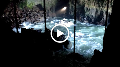
On Saturday we drove down the coast a bit to check out the sea lion cave. It is a huge sea cave where sea lions hang out; you can take an elevator down and ogle them. The scene is kind of like the elephant seal beach in Big Sur, but in a cave. They have a mesh fence up to keep the visitors separate from the seals. There is not much chance of disturbing them from a distance because it is crazy loud in there with the barking and the waves. While we were down there the elevator broke down so about 30 of us were trapped for 40 minutes while they tried to get a repair person out. Eventually they decided it would be too long to wait for a fix and we all got to go up the stairs. It was the twistiest spiral staircase I've ever encountered. You had to kind of sidle up with your back against the center pole. I kept picturing us all going down like a line of dominoes if someone at the top stumbled. 
Sea lion cave.

Sea lion cave movie.

After escaping from the sea lions we went for a short hike on the dunes. I would have liked to get down to the ocean but the path was flooded and swampy from all the rain. Still, we got to scamper in the sand which was fun. 
Nell on the dunes.


Sunday we headed home in scattered rain. We stopped a few times to look for agates and to check out Otter Rock. We glimpsed a few critters in the waves, but I think they were sea lions not otters.
View south from Otter Rock.

Otter Rock in repose.

Sunday, April 16, 2017

Catherine Creek hike

Brian and I hiked around near Catherine Creek yesterday. It is known for wildflowers March - May and we saw quite a few. I tried to take photos but the camera on my phone is definitely tuned for people and scenery shots, most of the flower shots did not turn out. Below are few of the better ones. I found the names on wildflowersearch.com, although any errors in ID are certainly mine alone.

I really like these upside down orange guys but I couldn't find them on the flower naming site.

Columbia Gorge desert parsley. We thought these guys looked a bit like the fennel that grew in Santa Barbara.

Poet's shooting star flowers.

Naked broomrape flowers.


Bigseed biscuitroot amongst the rocks. Sister to the desert parsley and also very fennel-like.
The hike itself was beautiful. We paralleled Catherine Creek for about 1/2 mile and got to hear it burble.The land had been used for sheep and cattle in the past and had some old wooden fences still and rolls of barbed wire about. The trail traveled through open meadow with large grassy areas and areas with rocks sticking out. It was a ~5 mile loop with 1500 feet of elevation gain. We could see down into the Columbia the whole way. About halfway up we got high enough to see Mt. Hood but it was covered in clouds. We got a better view from the Hood River bridge on our way home. 


View east up the Columbia.

Brian doing his thing.

Old livestock pen by Catherine Creek.